Wednesday, 18 May 2022

Marble Bar and Beyond


Leaving Nullagine, we continued on toward Marble Bar, another small outpost, with the unenviable catchline as the hottest town in Australia. A sign on the road into town proclaims, “a warm welcome from the hottest town in Australia.” Temps can reach 50 degrees for long stretches of time in the midst of summer. Thankfully it was not that hot as winter had just started.

Staying for just a look about, and a short detour to the famous Marble Bar in the creek outside town, which the town was named after. The marble is infact Jasper, mistaken for marble when first discovered, but the name of the town stuck.


Fueling up and topping up water, we indulged in a burger and chips from the roadhouse then took off.

The main road out goes to Port Headland, but a smaller track, called The Boreline Road heads further north and comes out on the main hiway between roadhouses. This was more our style of road, so without really knowing what the road would be like, off we went. Could always turn back if it was unpassable.


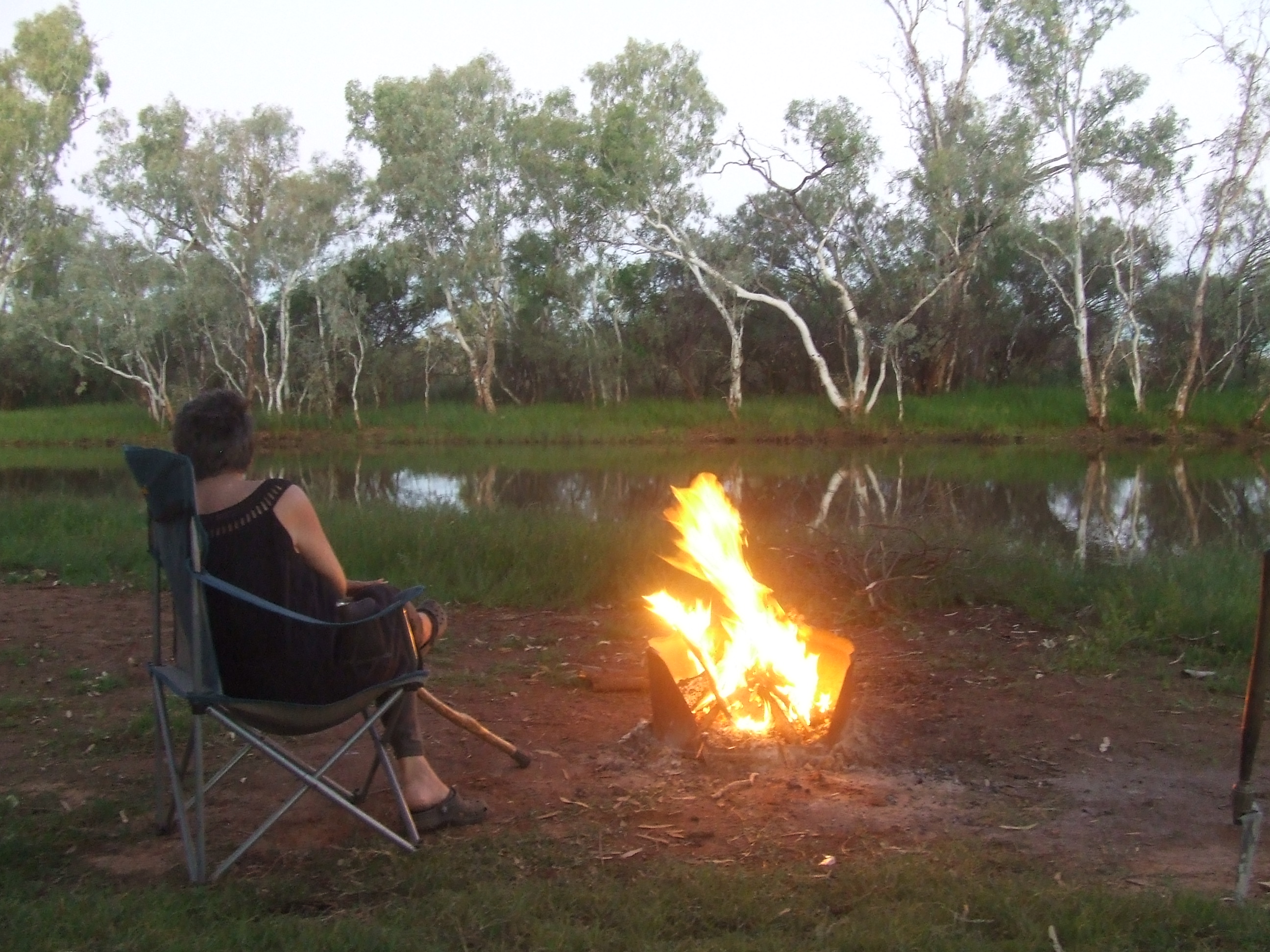
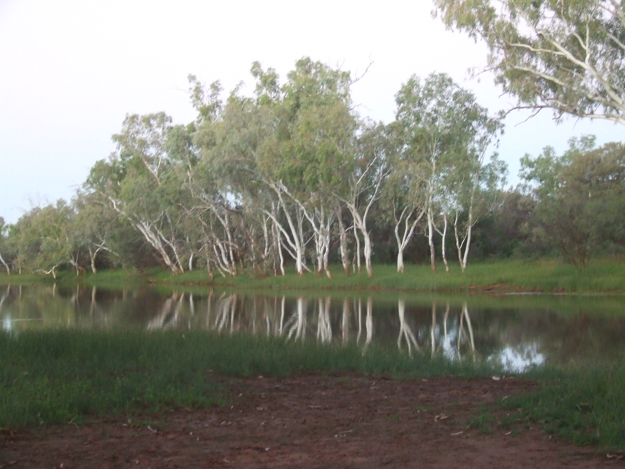
The road was good, as far as little used, outback gravel roads go. About 45k or so we came to a concrete causeway crossing on the DeGray River. A wide gravely river bed, with a trickle of water flowing over the causeway in the middle. On the other side, a track wound it’s way along the bank, sensing a camp, we investigated. Quite a way down, the water widened out and a clear spot, complete with a fire pit and firewood appeared. This would do nicely.


After setting up, I explored the surrounds, as I always do. The water was cool and clear, slowly running toward the crossing. Being a hot day, I succumbed to the temptation and stripped off and plunged in. cold at first but becoming nice and refreshing. I knew Din wouldn’t be persuaded to enter the water so I enjoyed it on my own. We were soon to enter crock country a bit further north and so this would probably be the last chance for a dip in a natural pool.

Taking advantage of the water and firewood we hung about for a couple of days and bathed and filled up our washing water.


On the last night it rained a little and the morning broke with overcast sky and the threat of more rain, so it was decided it was time to move.

Further up the road rain did appear, not heavy but keeping the day cool. A few soft patches on the road came up and further up a sheet of water covered the road completely. A 4x4 towing a caravan had stopped at the waters edge, he had overtaken us a few ks back. We pulled alongside and he said “what you think?” “I’ll go for a walk” I said.

The water was only out 200mm deep to about half way across and the surface of the road was solid, so we decided it would be OK. He jumped into the car and slowly headed off. I waited and watched his progress, on the other end the water got deeper but no problem. We followed.

Din had had a chat with the woman in the passengers seat while I was walking the water and she said she wasn’t happy they had taken this god forsaken road. Some people just can’t see the beauty around them. We love these roads.


Further up, another large body of water covered the road, which had turned to clay instead of gravel as it had been. Tracks up on the sloping edge told of others who had passed before, we both followed the tyre tracks on the thin, drier edge and made it across. This was to be the worst of the obstacles and we made it to the main HI way later that day.


Monday, 16 May 2022

Marble Bar Road


Having done our business, it was out of town and back to the solitude of the bush again. We pointed North and entered the Marble Bar Road. A wide graded gravel road used mainly by mining vehicles, with constant chatter heard over the UHF radio from the mine sites scattered about the reagon. Firstly passing through flat, plane country, then as you close in on Nullagine, about half way to Marble Bar, the landscape changes to rolling hills and jagged escapements of shining, dark, ironstone rocks. The rolling hills, typical of this Pilbra landscape, have their surface covered with spinifex clumps, resembling goosebumps on the bodies of reclining whales as you glide through the ancient land.


Nullagine, a small outpost supported by a gold mine close by, sits snugly amongst the spinifex covered hills. Before driving into town, we went to check out place called Garden Pool, a stretch of the Nullagine river with a permanent pool of water. Pulling up at the pool we were greeted with cool, green grass and shady trees, a perfect camp. This will do for the night. A small sign on the way in declared, no camping, something we normally obey, but this time we decided it was too good a spot to bypass.

After lunch we relaxed and soon the sound of a truck came down the track. Crawling past us, we noticed it was a council truck, checking the rubbish bins, it continued on, this we took as a sign that we could stay.

Late in the day, a group of aboriginal people came and sat at the picnic table not far away, one lady soon came over and asked if she could borrow a lighter. I obliged and we chatted, she and her friends were here for a federal hearing of aboriginal land rights of the area, being held the next day, right where we were. They left soon after and we had a meal and prepared for the night.

Next morning, a group of council workers turned up with trailers with porter loos and tables and marques, we presumed was for the coming hearing. An official looking bloke came over and said what was taking place there today. We told him we were preparing to move on and he said it would probably be best. We packed up, nothing being said about having camped there overnight, and drove into town a few ks away.

Have not heard anything about the hearing since. Local people, obviously trying to claw back some of their rights over the land they, and their ancestors have occupied for thousands of years, being challenged by hungry, fat cat, mining magnates sitting in offices in capital cities, who, rip, tear,and gouge tons of minerals from the pristine land, which is never put back to its former state.

Driving through the stunning country, then coming across mountains of bare, overburden, contrasting against the natural beauty of the surrounding landscape, makes you feel sad for the land these native people have cared for for, millennium.

OK, rant over.

Nullagine is only small, we climbed the hill in town and took in the view from the look out. A council truck arrived, the same one we had observed the previous day on the river. They got out and checked the bins and one said to Din,”They kick you out of down there?” referring to the campsite. “Yes,” Din said “Should have asked him if he owned the place.” They both laughed.


Bilyuin Pool


Around 70k north from Meekathara is a permanent pool of water in the Murchison River system, called Bilyuin Pool, this was our next place of interest to see.

On finding the pool, we camped up at a nice spot by the water. A family of ducks glided by in the water and soon after a pair of black swans came in for a splash down landing not far away. What a bonus. Other birds chirped around us, an oasis in a parched land. Water, the giver of life, without it this would be a lifeless depression in the scorched earth.


Soaking up the tranquillity, we hung about for three days, then, with the patchy reception on the phone we got a message from, who else but my sister, they were heading our way and wanted to know if we needed anything. Whilst shopping in Meekathara, I had forgotten to buy a roast, Din was hanging out for a roast dinner, so we asked them to get a roast beef for us. She texted back, are you sure, 2kg one was $76.00. Dins craving was strong, to hell with it we said, get it.


They arrived and handed over the precious beef, on inspection it wasn’t encrusted with gold as I had expected. Next morning a fire was lit and camp oven, veges and meat were prepared. When enough coals were present, the meat, in the camp oven was placed on a bed of coals and a shovel full placed on the lid.

By lunchtime the meat and veges were cooked and I was stirring a good quantity of home made gravy while a damper was finishing off in the smaller camp oven on the coals.

Dins cravings were at last satisfied, the meal was a hit, loved by every one. Just because you are roughing it in the bush doesn’t mean you have to do without.


Another day lazing by the water and it was time to move on. Thanking us again for the wonderful lunch, my sister packed up and left before us. They were heading west, to the coast, and then around towards NT and Darwin. We were going North to Newman and then Marble Bar. But first a detour to a former gold mining town called Peak Hill.


Peak Hill is now a collection of stone ruins beside a fenced off open cut mine pit.youu can drive around the old buildings and imagine the bussel of life in those times. We pulled up at the edge of the old pit and I scaled a couple of dirt mounds and was confronted with a huge tiered hole with a ominous dark pool of water in it’s depths.


This old mine had long been abandoned, but will probably be reworked in the future. On we went and some ks down the track came to another pool just off the road. Waterside camps are rare around here, so this was our next camp.


Another good stay, onward to Newman, a mining town not unlike all the others, although handy for resupplying, having a supermarket and all we need.


Friday, 6 May 2022

Wiluna and beyond


Wiluna is a small town in the middle of nowhere. Mainly known as the start of the Canning Stock Route, a ruggard 4x4 track crossing hundreds of sand dunes and traversing the dessert ending up at Halls Creek. We were heading for Halls Creek, but this track was a bit beyond Ned's capabilities in his present form. One day we hope to negotiate that track, but not today.

Covering the distance from the Granites to Wiluna fairly quickly, we stopped in at the store and topped up the fuel. I asked the attendant if I could swap a small gas bottle as we had run out the day before. He just said nah, you have to go to the shed over there, pointing to a shed over the road.

After paying for our stuff, I drove the truck to the pointed out shed and asked a man in the yard if I could have a gas bottle. He said no, we only have empty ones here. Asking if anywhere had some, I got no, again. Shrugging my shoulders, I thanked him and turned to go, he said, I have one with some gas in it around back, you can have it if you like. I thought for a bit and said OK, it would be appreciated. He gave me the cylinder and said, I saw nothing, thanking him again, we were off.

The road to Meekathara from Wiluna is a corrugated, gravel road, with short sections of buitumin.


We were overtaken a few times by what we assumed were locals driving small, and medium sized town cars which were a bit worse for ware. One car came whizzing past, having no windscreen or back window glass and looked very much like it had been rolled and they had simply put it back on it’s wheels and kept driving. This is the outback.

Meekathara crept into view over the vast flat plains, another small town servicing the surrounding area. Filling up with water, we headed to a free camp a couple of k out of town called peace gorge. A large area amongst a scattering of granite outcrops. Selecting a nice spot we camped up. Having filled up with water, we decided it was bath time. There was wood for a fire,so , with out wasting time, a pot full of water was put on to boil and the shower tent erected. Spent the next few days there relaxing and taking in the beautiful surroundings.


Packing up again we headed into town where I grabbed some supplies from the store and refuelled, then, northward again toward Newman.


The Darlot Loop


Heading north from Leonora you can take a road promoted by the tourist info mob in town, known as the Darlot Loop. This road goes out from Malcolm Dam and loops around in some interesting country and finds its way back to town about 230k later. We weren't going back to Leonora, but would leave the loop at a point where we could continue our northern course.

A way down the track you come to a place called The Terraces. These rugged outcrops of rock are continually being eroded by the elements and stand proud and intimidating amongst the surrounding flat terrain. We explored a couple of the canyons we could access and were heading out of one such place, when a ute appeared and stopped to see if we were lost. Reassuring him we were not he proceeded to tell us of a great spot a little further on. Thanking him for the info, we took off in that direction. Down a winding, narrow track we came out in a clearing surrounded on three sides by towering ancient cliffs, their faces scared by the ravages of time, caves, peering down at us from high above like gaping eye sockets in the bare bones of the cliff faces. Colours of the rocks ranged from dark red to lighter orange all the way to gleaming white, truly a beautiful place.


I wandered the canyon, climbing some rock faces and poking into a few shallow caves. Ascending the wall along an animal track following a less steep gradient I emerged on top of the cliff face, looking back down to where Ned and Din stood looking back like small toys in the canyon below. I scouted about along the rim, flat scrubby country one side and a gaping hole on the other, at times like these you feel a bit insignificant, a small speck on an expansive landscape, like no one is about for hundreds of miles, and there probably isn't.


Spent a couple of nights there, under a clear star filled sky, then reluctantly packed up and moved on.


Further down, the track moves through more gold mining and parstrol country. For the 150k or so we had been on this track, again, we had not come across a soul. Up ahead was a stand of tall eucalyptus trees, standing amongst the low mulga scrub. These were pointed out on the info sheet obtained from tourist info in Leonora, as one of the last stand of these trees in this sort of country.


It was getting late, so this was our camp for the next couple of days. Before leaving Leonora, we had filled the washing machine, a small bin with a lid, it had agitated well on the uneven road to here, so now was a good time to wring it out and dry it. Also we were getting low on cold meat, so a fire was built, a pickled pork defrosted and put on to boil.

Moving on again, we next came to a rock outcrop called the Granites. These were different to the Terraces in that they looked like a giant had given up on a game of marbles and discarded his toys in a pile on the ground. Boulders of all sizes lumped on top of each other and strewn across the landscape. Weathering and erosion again had formed this ancient pile. Nice spot for a camp, so we did.


Next day we heard a vehicle pull up. Getting dressed, it was a bit warm, I poked my head outside, it was my sister, they had taken the same road and had caught up with us. 


My brother in law explained how they had followed our tracks most of the way, we were the only vehicles on that road. Spent that night there with them, the sunset was spectacular, the photos don’t do it Justus


.

  They took off in the morning. We were heading to Wiluna, northward, and they were going west for a bit to Cue.


Leonora


After leaving Zanthus and travelling to Kalgoorlie, we caught up with our friends again then north again. Leonora, the next destination. Last time we had been to Leonora was that 20 and some years before, when we had been forced to stop at the caravan park while I made repairs to a broken axle on our caravan which had snapped just as we emerged from The Great Central Road starting from Uluru N.T. the town had grown. We headed some 15k out of town to Malcolm dam, where we had also camped at, at that time. The area had not changed that much, though there was less water and now there were some shelters and tables scattered about. Also bins were provided, but it seemed no one used them, litter was everywhere. On the flat of the dam, the red earth was bare, but the rubbish had blown in amongst the low surrounding mulga scrub. While we were there we collected a total of three large rubbish bags full and placed them in the bins. Why cant people take out what they bring in, or at least use the bins?


While at Leonora we again met up with my sister, they were also travelling north, heading for the NT. This was also our long term destination, though we were going a different way. At reaching Halls Creek, we would head east taking the Tanami track 1000k to Alice Springs, where they were taking the main road to Darwin.

On the Tanami there is a distance of 850k between fuel stops, as at this time no one could enter aboriginal community. I had purchased some materials in Kalgoorlie to fit another rack under the tray of the truck, and a jerry can to put in it, so we were assured of carrying enough fuel to do the track. At Leonora I fitted the rack and was confident we could make the distance.


Gawlia is an old gold mining town a few ks out of Leonora, only a few people live there but a gold mine is still present, a huge open cut affair now. 


The old shacks of the former town have been restored and put on display so you can stroll around and get a glimpse of the way of life in the 1800s .


We spent the day with my sister and explored this town trapped in time.