Thursday, 3 July 2025

The Gunbarrel Day 1


Warburton road house loomed in the distance as we bumped down the Great Central Road, having just come across form Wingellina and our mining camp resort. This was to be the last fuel stop for another 800 or more ks, so all tanks were filled and we set off again.

The turn off for the Gunbarrel was 20k up the road, finding a pull off about 15k up, camp was set. With a superb desert sunset firing rich reds across the horizon, we settled down for the night.

 Waking in the morning, with anticipation we set off for the turn off. The Gunbarrel is a well-known track pushed through the desert by Len Beadell when he did the roads for the atomic test sites at Maralinga in the 50s and 60s. It hasn’t been maintained since and is known for its rough condition with closed in bush along its length. There are some bores with hand pumps scattered along, but some don’t work, so you have to be prepared and self-sufficient, we were.


Turning off The Great Central Road we ambled up The Heather Highway, which would take us, firstly West, then North to meet up with the Gunbarrel proper. Camels were sighted along the road, grazing on the verge, moving off as we approached.


90Ks of bone rattling corrigations and we hit the track we were looking for. Another 10 or so, a plaque on a tree caught our eyes, one of Len Beadell's markers he put at strategic places on all his roads, marking directions and milage to key points from that position. Opposite the tree was a track into the first bore. We followed it in and set up camp for the night.


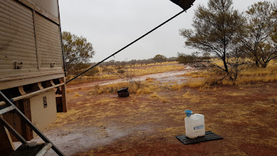
Unfortunately, the pump on the bore didn’t work, but we were full of water anyway. In the morning, dark clouds were forming and soon, spits of rain fell. As the morning progressed, so did the rain, as it was only going to be this weather for that day, we elected to stay put and wait it out.

In the morning, the clouds had gone, the surrounds looked crisp and washed. Some of the gums were flowering and put on a great display. The ground was wet, but not boggy, so all was good.


Standing outside, I could hear a low gurgling rumble a little way off and recognized the call of a camel.

 Walking out of camp for a way, into a small clearing, I could still hear the camel in the distance. Then I saw, in the bush, the start of the herd galloping across the plain. Others followed, maybe I had spooked them, or the calling male was in the mood and the girls weren't.


After breakfast, we packed up and prepared for another day on the Gunbarrel.


Wednesday, 2 July 2025

ALICE TO GUNBARREL


Next stop Yulara. After a roadside camp we rolled into Yulara, then promptly fueled up to full capacity, fuel tank and all 7 jerry cans full, the way we were going, fuel stops were few and far between.

  Out of Yulara and on to the Docker River Road, the start of the Great Central Road.


 We had travelled this road before, some 29 years before, and were a bit saddened at the improvement of the road. Now a wide graded gravel road, vastly different to the corrugated rough track we had traveled so long ago. Took some of the adventure out of it, well to our mind anyway.

 Soon we were at Docker River Community. A run-down campground is just past the entrance to the community, and we pulled in for the night. It is a free camp now, but once it was a paid camp with toilets and hot showers, but the bore suppling water there had gone dry, so all the toilets and showers were locked up unusable. Never mind, it was in a nice setting, amongst the gums very pleasant.

 In the morning, always looking for an opportunity, a couple of locals came around wanting to know if we wanted to buy some paintings done by them. They were good and just up Dins ally. After a bit of haggling, we bought one, all were happy with the deal, and they took off with a beep of the horn. Soon after some more came over and offered a deal not to be refused. To their disappointment, I informed them the others had all my money, they left without a beep of the horn.

 Packing up, we headed west. Giles Mulga Park Road was about 75k down the road, this would take us to Wingellina,


Wingellina, the community where our friend's mining camp was just outside of. With the aid of our Starlink technology, we gave him a ring and told him we were on the way. He was pleased to hear from us and said we were welcome and gave us directions to the camp.

 Rolling into the camp in the afternoon we met up and he directed us to the back of the buildings to park up, then pointed us to the showers and said meals are on soon, come and have a feed. Luxuray, for us, so we partook of the welcome showers and fronted up for a feed.

 He worked there alone, catering for the five or six workers in the camp for a four week on four off basis. And what a great cheff he was. Every one of the workers we spoke to praised his work and always looked forward to his shift. He also had created a herb and vegy garden outside the mess hall, with all types of plants thriving in this harsh envioroment. The workers water his gardens when he isnt there.


It was a small camp, doing drill testing for minerals in the area. The next day one of the workers offered to take us to the CORNER, where the three states meet, and he also took us up to the top of a hill nearby for a look. There had been exploration done many years ago and the rocks uncovered then were all about. Don’t know what they are called, but they look spectacular, with blues, green and purple hues.


We stayed for 2 days and were thoroughly spoil, even with Dins favorite, a roast dinner, on the last night. With many thanks, we bid farewell, our time at the camp tucked away with our favorite memory’s.


Westward we rolled, on the Blackstone Warburton Road. We only got about 15k out when we came across a small car in the center of the road. A few locals were sitting in the scrub on the side. I stopped and called out, you, OK? The old fella came over and said, no, we run out of petrol. I explained we only had diesel, he looked around a bit and said, yeah. A younger girl, I assume was his daughter, came over and said, you going to Blackstone? Yes, I said, and it was agreed we would let someone there, know of their plight.

A bit down the road a convoy of about 6 station vehicles came from Blackstone way heading toward them, so we knew they would be taken care of.


That afternoon we came to a Canter truck on the side of the road with a burnt out cab. It had been there for a while, partly scavenged, as are most of the wrecks out here. We camped for the night off the road and in the morning, I obtained a few parts for Ned, along with one, which I had been looking for, for a while. The road was dotted with wrecks in all sorts of condition. Some on the road, some just off, I say it's the community’s auto parts store, they know where to get the part they need.

 The road ends at Warburton on the Great Central Road, where, not too further on, the Gunbarrel Highway starts. Its called a highway, but it is no more than a couple of wheel tracks heading west to Carnegie Station, 300k east of Wiluna, and that, is where we were going.


Tuesday, 1 July 2025

Old Andado to Alice Springs


Cloudy skies and an ominous weather report predicting rain in the area surrounding us made us rethink the couple of days camp we had planned. The road, while in good condition, would quickly turn into a problem with only a small amount of water on it. With some 330k to transverse to Alice Springs, we decided the best thing to do was to go now while the road was still dry and hope we beat the rain.

 The dusty road was reassuring, even with rain clouds on the horizon. Being in good condition, we made good time along the gravel road. Unlike us, we kept going and the Ks rolled by. Passing through a few light showers it seemed we were in for a wet time of it. Fortunately, the outskirts of Alice came into view, and we made it without incident.

 Camped up behind the Road Transport Hall of Fame, we waited and watched the forecasts. It wasn’t looking good, unseasonal heavy rain was sweeping across the top end of Aus again, and Alice was in for it too.

 Feeling the need to get out of town, we headed up the highway to a rest area on the tropic of Capricorn. The next few days were very cold and wet. Hunkering down we closed up and put the diesel heater on and waited it out.

 Clearing skies gave hope and the forecasts said we were over the worst of the weather. But, the Tanami road was closed due to flooding, this was the road we had come so far to travel down. It wasn’t going to open anytime soon, so, plans had to change.

 Instead of attacking the Canning from the north, it was decided, we would go from the south. This would give the north end time to dry out before we got to it, and we could get to Wiluna from Alice by going west.

 A friend we met in Tassie worked at a mining exploration camp as a cook for the workers at Wingellina, right at Surveyor Generals Corner, where Northern Territory, South Australia, and Western Australia meet. Before we left Tassie he said if we were ever about when he was on shift we were welcome to go and camp up at the camp.

With a phone call and a chat, it was confirmed he was indeed at work, and he said come on over.

 It was a plan then, go to Uluru then onto the Great Central Road to Docker River, then south along the Giles Mulga Park road to Wingellina and the corner. From there we could travel west to Warberton and then onto the Gunbarrel all the way to Wiluna. A plan.

 The weather, having cleared up, let us go back to town and get the supplies needed, as this would be the largest town we would encounter for a very long time.

 With a truck load, literally, of food,fuel,water, and anything we could think of,the road out of town beckoned, so off we went. We had it all, except for beer!!!!!!!, the licensing laws don’t allow alcohol outlets to open earlier than 3:oo pm and it was still early in the morning. So I resigned myself to a dry trip for the time being, probably do good.

Friday, 27 June 2025

Tassie to NT


With our summer in Tassie drawing to a close, we focused on the next adventure. The Canning Stock Route, for a long time now it had been on our bucket list. During the summer months in Tassie I had been preparing for this trip. Maintaining Ned the truck and gathering the things needed for an extended remote and isolated trip.


A winch was added to Ned, and extra fuel containers purchaced, as well as a lot of other things such as sand tracks for getting unstuck in soft sand. Spring bushes were replaced and a full service performed.


The Canning, from Wiluna in the South to Halls Creek in the North of WA is considered the longest and most remote 4wd track in Australia, if not the world, at 1800k long and around 900 sand dunes to transverse, it has only one spot,1000k from Wiluna to refuel, so carefull preperation is key.


Unusal heavey rain in the north of Australia had soked the northern part of the track, so it was unsure if that part would dry out for us to travel on. By the time we got to there it may be alright, we had options to go elsewhere if it wasnt.


Back on the mainland, our plan was to cut through Victoria to South Australia and head up the Oodnadatta track and track north from Oodnadatta to Mt Dare and into Northern Territary and onto Alice Springs, then up the Tanami Track to Billiluna, the northern start of the Canning. SSo off we went.


After a visit to Deb our friend in SA we headed for the Oodnadatta Track. First point of intrest for us was Lake Eyre, with all the rain, the lake was filling from the northern water coming down.

Pulling up at Lake Eyre South no water was visible, we were a little early, but it was on its way.


So it was onward for us. Taking our time, as usal, we meanderd up the track, camping at ruins of sidings along the old Gahn railway along the way. One of our camps was at Algebukna Bridge, a long steel railway bridge spanning a small river along the old railway line.


Some days later the buildings of Oodnadatta appeared on the horizion. Rolling into town, we pulled up and did the usal, fuel up, got some supplies as well as a coffee and snack. 


After asking about the track to Mt Dare and finding out it was all good to go it was back to the road. Firstly though, Din got some postcards and posted them to the grand kids.

Turning north, Ned pointed his nose up the Mt Dare road. We went as far as Hamilton station then turned east along the Perdirka track which takes you past the old Dalhousie homstead ruins, then on to Dalhousie Springs, a system of hot springs in Witjira National Park.


Comming up to the homestead ruins, date palms stood proudly amongst the slowly crumbling stone buildings. Stone walls defying the elements to do their worst, still standing after all this time.


After a walk through the past, we bumped our way down the track toward the springs. There is a large campground at the springs and a wooden dock where you walk out and down some stairs into the artesian warmed spring pool. Setting up camp we enjoyed the solitude, with only a few others scattered about in the campground. In the mornings, steem rises from the surface of the water creating a mystical scene in the early light.


Making it to Mt Dare the next day we opted for a campsite and a shower. Firstly, though it was a cold drink and a Mt Dare burger at the famous Mt Dare pub. The shower was welcoming, and we enjoyed a relaxing afternoon.


Refreshed and keen, the next day we headed north along binns track toward Old Andado in the Northern Territory. Mack and Molly Clark built Old Andado Station way back. It was the most remote station at the time, it is still verry remote, their son built a new homestead down the road a bit and the station now runs from there. After Macks death Molly stayed on at the old homestead and lived there alone till she died too. 


Now through a group of volinterrs, the homestead is preserved just as Molly left it. She is at rest just over the lagoon, looking back and watching over her family home.


 A campground is in the yard, and you can wander about soaking up the atmosphere and feeling how it was living there, which we did. A wonderful piece of preserved history.


Sunday, 20 October 2024

Danggali to Renmark


Crossing the Barrier Highway, it was back to the station roads we are so fond of. Endless skies, red dirt plains and splashes of colour from patches of wildflowers kept our spirits high as we weaved our way over the dusty roads. When navigating these roads, you pass station homesteads, some are some ks from the main road but some are close, such as Quondong Vale, where you pass right by their front door and nearly go through the machinery shed. Bush etiquette is you slow right down and try not to create dust, common sense really. Lucky for them, there is not much traffic on these roads.


Soon we were at the turn off which would take us through Danggali conservation park. This area we had traveled before, we took a different track through this time, a less difficult route but none the less interesting.

On our first camp, we had set up and were enjoying the solitude, when a father emu and a brood of no less than nine chicks wandered close to us. They seemed unafraid but cautious. We watched as they nosed around, then the kids found a bush close by and started pecking at it with relish. Father soon joined them, and they spent some time picking the fruit, or seeds off the bush. When they had had their fill, they wandered off, contented. Another sight we were lucky enough to observe.


All too soon we were back on the bitumen and on the outskirts of Renmark. Moving on, then stopping at Berri, we stocked up on food and water, then found a familiar camp on the Murray river for a couple of days rest, before we headed to Deb and the camels for a visit.


Thursday, 17 October 2024

Strezleceki


Innaminka, in South Australia, just over the border from Qld, is a small, so called town, mainly servicing the oil and gas fields and pastoral properties in the area, mainly comprises of a servo and a pub.


After topping up with water and fuel, we continued our trek, turning south, the Strezelecki track stretched before us into the distance. In the early days, the track, from Innaminka to Lyndhurst, a distance of over 400k, was all dirt, now there are long stretches of bitumen, mainly because of the oil and gas fields and the increasing number of trucks using the road.


Our journey along the track would take us about 200k down, then turn off and travel along station roads skirting the Gammon and Northern Flinders Ranges along their eastern side.

When the bitumen ended the familiar rattling of the corrugations and billowing dust clouds began. It didn’t take long till I stopped and let the tyres down to cushion the bone shaking effects of the rough road, with this done and a much lower speed, the ride became more bearable.

About 100k from Innaminka, Moomba, with towers of pipework and other structures, like a city skyscape in the flatness of the desert came into view. With this base of operations for the surrounding gas fields came an increase in truck traffic on the road. The double and triple trailer road trains rumble toward you, signaling their presents with a cloud of dust on the horizon. It is best to slow right down and get off the road to let them pass. Depending on which way the wind is blowing, you ether get lucky and miss their dust trail or get swallowed up in the white out of their wake.


A camp for the night at Strezelecki Creek crossing, finding a patch of shade on the eastern side of a tree on the creek bank, we hid from the heat of the sinking sun. the days in this area were hot and getting hotter, reminding us it was getting too late in the season to be out in this country.

After a cool nights rest, some 50k further on, the area called the Cobblers appeared. The Cobblers are dome shaped mounds of sand forming small dunes around clumps of Nitrebush. They presented a nightmare to early explorers and settlers trying to navigate their way through this maze of lumps in their way. Today the road has been bulldozed through them.


Another 50k on we came to the turnoff to Mt. Hopeless, where we turned off. With less traffic on this road, it was a lot smoother to drive. Across the Strezelecki Desert we drove till the outline of the Gammon Ranges appeared on the otherwise flat horizon. As we passed Moolawatana station homestead ,on the right, a track led off to the distant hills. Knowing the track from a previous trip, we took it and in a few ks came to Terripina Springs, a creek cutting its way through a rocky ridge line. This would be our camp for the night.

Under the shade of the river gums, with the red cliffs towering on both sides and the silence hugging us, we checked out the pool of permanent water, fed by a spring under the rocks in the creek bed, then rested and gave thanks we could experience such beautiful places.


Next day it was back to the station tracks, passing between Lake Frome and the Ranges, heading South, eventually reaching Yamba on the Barrier Hwy, fueling up, we crossed the Highway and continued south, again on station roads, our sights set on reaching Danggali Conservation Reserve and crossing through on our way to Renmark.